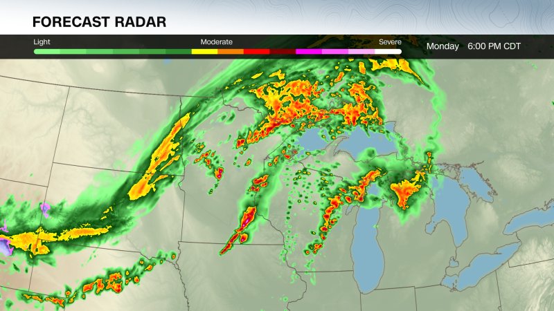
Millions in the Upper Midwest face the possibility of a severe thunderstorm outbreak Monday that could bring rounds of dangerous storms capable of unleashing damaging winds, large hail and strong tornadoes — the start of several days of extreme weather threats across the country this week. The first batch of severe thunderstorms started to take shape in the afternoon and evening in Minnesota, Iowa and Wisconsin. Damaging storms are also possible in parts of the Mississippi Valley and Plains, putting more than 35 million people at risk of dangerous weather from Texas to northern Minnesota. Tens of millions more could be in the path of severe thunderstorms Tuesday as the potent storm system driving Monday’s threat surges east. A few non-severe thunderstorms bubbled up early Monday afternoon in the Upper Midwest and Plains and the atmosphere kicked into high gear not long after. At least one severe storm dumped egg-sized hail in far southwestern Minnesota by mid-afternoon. Storms in parts of Minnesota, Wisconsin and Iowa – where a level 4-of-5 risk of severe thunderstorms is in place, according to the Storm Prediction Center — could become the most dangerous of the day. The cities of Minneapolis and St. Paul are under this risk level. Strong tornadoes — rated EF2 or greater — are possible for areas under the SPC’s level 4-of-5 risk and for some areas within its level 3-of-5 risk. The late afternoon and evening is the “most dangerous period” when “strong tornado potential should be maximized,” the SPC warned. More than five million people across eight states in the Central US are under tornado watches as of Monday afternoon, including in Minneapolis and Rochester, Minnesota; Des Moines, Iowa; and Oklahoma City. Four separate tornado watches are in effect for parts of Minnesota, Iowa, Wisconsin, Oklahoma, Texas, Kansas, Missouri, and Nebraska. Storms may produce hail larger than baseballs and wind gusts of 75+ mph, according to the SPC. Additionally, tornado warnings were issued Monday afternoon covering parts of Minnesota, Kansas and Iowa, according to the National Weather Service. Thunderstorms could arrive in two waves in some of these areas, with each round packing its own serious punch. A few of the storms that fired up mid-afternoon ahead of an advancing cold front could still become violent supercells — essentially the most extreme form of thunderstorm. Storms will continue to intensify over the next few hours, the National Weather Service in Minneapolis warned Monday afternoon. Even if they don’t, the Upper Midwest will see a round of powerful thunderstorms roar to life by the evening as the cold front slices through. This line of storms could unleash widespread damaging wind gusts, hail and tornadoes. While these tornadoes may not be quite as strong as any spawned by the supercells, they will still pose a great danger. Other parts of the country have been extremely active: At least one tornado has occurred somewhere in the United States each day for nearly two weeks straight. This year is also pacing at the second-highest number of tornado warnings on record to date – only behind 2011. Other thunderstorms could rumble to life later Monday afternoon and evening from Kansas and Missouri to Texas. Some of these storms may not be as fierce as those farther north, but could still deliver powerful wind gusts, large hail and tornadoes. Strong tornadoes are possible in far northeastern Kansas and northern Missouri – just north of the Kansas City metro area. Severe threat shifts east Tuesday, with over 1,800 miles of the US at risk Some of Monday’s thunderstorms will continue overnight and into early Tuesday morning, likely losing their potency with time. But a renewed severe thunderstorm threat will unfold Tuesday afternoon. A vast swath of the country more than 1,800 miles long from West Texas to Vermont is within a level 2-of-5 risk of severe thunderstorms on Tuesday, with a smaller but more significant level 3-of-5 risk for parts of Ohio, Pennsylvania and New York. It’s a setup putting more than 45 million people at risk of dangerous weather. Thunderstorms could develop in the afternoon in parts of Texas and Oklahoma while farther north, the same system that brought Monday’s severe weather ignites new storms in Canada and parts of the Midwest. Storms that develop Tuesday afternoon will likely start in southern Ontario and then track into parts of Ohio, Pennsylvania and New York in the evening. Damaging wind gusts are the main threat with these storms, but some could drop large, egg-sized and tornadoes. A flash flood threat will build in tandem with Tuesday’s storms in the Plains and Mississippi Valley. A level 3-of-4 risk of flooding rainfall is in place Tuesday for portions of Texas, Oklahoma — including Oklahoma City — Kansas and Missouri, according to the Weather Prediction Center. Heavy rain late last week and over the weekend drenched the ground in these areas, making them much more vulnerable to new bouts of soaking rain. Those storms caused flash flooding that turned deadly the prior weekend in Oklahoma. Stormy weather and periods of heavy rain will persist Wednesday, with a level 3-of-4 risk of flooding rainfall in place for parts of Texas, Oklahoma, Missouri and Arkansas. A few severe thunderstorms are possible in the southern Plains on Wednesday, but chances for disruptive storms start to fade for the rest of the week.
Where a severe storm outbreak could spawn tornadoes, large hail and damaging winds tonight
TruthLens AI Suggested Headline:
"Severe Thunderstorm Outbreak Expected in Upper Midwest with Tornadoes and Hail"
 CNN
8.6
CNN
8.6
TruthLens AI Summary
A severe thunderstorm outbreak is expected to impact millions in the Upper Midwest on Monday, with predictions of dangerous storms capable of producing damaging winds, large hail, and strong tornadoes. The initial severe thunderstorms began forming in the afternoon and evening across Minnesota, Iowa, and Wisconsin, posing a threat to over 35 million people from Texas to northern Minnesota. The Storm Prediction Center has issued a level 4-of-5 risk for severe thunderstorms in areas such as Minneapolis and St. Paul, indicating a high likelihood of strong tornadoes, particularly those rated EF2 or greater. As of Monday afternoon, more than five million people across eight states are under tornado watches, including locations such as Des Moines, Iowa, and Oklahoma City. The storms are expected to intensify, with potential for hail larger than baseballs and wind gusts exceeding 75 mph, which could lead to widespread destruction as multiple rounds of severe weather develop throughout the evening.
As the severe weather threat shifts eastward into Tuesday, more than 45 million people are at risk across a broad area stretching over 1,800 miles from West Texas to Vermont. A level 2-of-5 risk will be present across many parts of the country, while a more concentrated level 3-of-5 risk will affect portions of Ohio, Pennsylvania, and New York. Thunderstorms are forecasted to develop in the afternoon, initially in Texas and Oklahoma, before moving into the Midwest and Canada. The primary threats from these storms will include damaging wind gusts, large hail, and the potential for tornadoes. Additionally, a flash flood threat is anticipated due to heavy rainfall from previous storms making the ground more susceptible to flooding. This week has already seen a high frequency of tornado warnings, with 2023 on track to record the second-highest number of tornado warnings in history, only surpassed by 2011. As the week progresses, storm activity is expected to continue, particularly in the southern Plains, although the chances for severe storms are anticipated to decrease later in the week.
TruthLens AI Analysis
The article provides a comprehensive overview of an impending severe storm outbreak in the Upper Midwest, detailing the risks posed by extreme weather, including tornadoes, large hail, and damaging winds. It emphasizes the urgency and seriousness of the situation, particularly for millions of residents in affected areas. The focus on the potential for severe weather serves to inform and prepare the public for what could be life-threatening conditions.
Purpose Behind the Publication
The primary aim of this news piece is to alert the public about the severe weather threat, ensuring that people are aware of the risks and can take necessary precautions. The article seeks to foster a sense of urgency among readers, encouraging them to stay informed and vigilant. By providing specific details about the areas at risk and the nature of the storms, it aims to enhance public safety.
Public Perception Shaping
This type of reporting can create a heightened sense of awareness and anxiety regarding natural disasters. The language used, especially terms like "severe," "dangerous," and "threat," can lead to an increased perception of risk among the general public. The article may also foster a sense of community as people in affected areas prepare collectively for the storms.
Possible Information Omissions
While the article focuses on the threats posed by the storms, it may not address the preparedness measures or resources available to communities, such as shelters or emergency services. This omission could lead to feelings of helplessness among readers. However, the primary focus seems to be on raising awareness rather than downplaying the severity of the situation.
Reliability Assessment
The article appears to be reliable, as it references the Storm Prediction Center (SPC), which is a credible authority in meteorological forecasting. The use of scientific terminology and risk levels also adds to the reliability. However, the inherent nature of weather reporting can sometimes lead to sensationalism, which might affect public perception.
Community Engagement
The article likely resonates more with communities that are accustomed to severe weather events, such as those living in the Midwest. These communities may be more inclined to heed warnings and prepare accordingly. Conversely, individuals in regions less familiar with such phenomena may experience confusion or disbelief regarding the severity of the storm threat.
Economic and Political Implications
The coverage of severe weather can have significant economic impacts, particularly in areas where agriculture or outdoor activities are prevalent. Businesses may face disruptions, and insurance claims could soar following damage from storms. Politically, effective communication about disaster preparedness can influence public trust in government agencies tasked with emergency management.
Market Impact
The severe weather forecast can influence industries such as agriculture, insurance, and construction. Stocks related to weather preparedness, such as home improvement or emergency supply companies, might see fluctuations based on public response to the forecast.
Global Power Dynamics
While the storm outbreak is primarily a domestic issue, it does connect to broader discussions about climate change and its increasing impact on weather patterns globally. The article reflects a growing concern regarding extreme weather events, which aligns with recent discussions on climate resilience and adaptation strategies.
Use of AI in Writing
There is a possibility that AI technology was utilized in crafting this article, particularly in data analysis and weather forecasting. AI models could have helped predict storm paths and severity, enhancing the article's accuracy. However, the narrative style suggests a human touch, ensuring the urgency of the situation is communicated effectively.
In conclusion, the article serves its purpose of raising awareness about severe weather threats effectively and relies on credible sources to convey information. However, it could potentially create anxiety in communities unaccustomed to such weather. Overall, it reflects the importance of preparedness in the face of natural disasters.