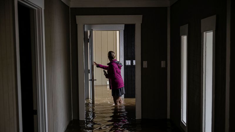
Rising river levels in Kentucky are prompting evacuations and warnings to move to safer ground, with water rescues under way in flooded areas. The National Weather Service earlier this week warned of the possibility of “generational” flooding, stemming from a stagnation in the current weather pattern that’s caused a string of storms to repeatedly hit the same areas in the Central and Southern US. A line of violent storms has swept from Texas to Ohio, leaving at least 19 dead across seven states since Wednesday. On Saturday, Kentucky Gov. Andy Beshear declared a state of emergency, citing potentially record rainfall in areas unaccustomed to flooding. “We need everyone statewide to take this seriously,” Beshear said. Residents in low-lying areas of Frankfort, Kentucky, are being warned to prepare for potential flooding as the Kentucky River is predicted to crest at a historic high on Monday – just shy of the level flood walls are built to protect against. “The flood wall system is designed to withstand 51 ft of water, assuming all sandbag lines, temporary protection and levee closure structures are in place,” the city said in a media release. “The current river crest is predicted at 49.5 feet, which is the highest recorded in history. At this level, these areas of uncertainty MAY flood. Roadways in these areas have the possibility to be water covered and inaccessible. Basements and lower level floors may get water,” the city government warned. Frankfort Mayor Layne Wilkerson enacted a curfew for flood-affected areas starting at 8 p.m. Sunday. The curfew will last until 6 a.m. on Monday. The curfew was “a necessary measure to ensure public safety, prevent looting and vandalism, and allow our first responders and recovery teams to operate efficiently,” Wilkerson said in a statement. In a video updated posted to Facebook, the mayor said that emergency management, police, fire, members of the National Guard had been going door to-door to ensure residents understood the situation. “We want to make sure that people know that if they have an opportunity to evacuate and can go to another area – it’s better to be safe than sorry,” Wilkerson said. He added the water treatment plant was not functioning and urged the community to conserve water with only a couple of days supply on hand. Franklin County Judge Executive Michael Mueller said in the Facebook update that his heart went out to everybody who had lost their homes. “This is a devastating storm - number one in history in Franklin County.” he said, adding that city, county and state offices would be closed for at least Monday. Drone images of Frankfort on Sunday show devastation from the floodwaters of the Kentucky River. The Buffalo Trace Distillery, one of the businesses affected, said it would be closed through Thursday. “Due to the unprecedented and ongoing rain and flooding, we are not able to advise on the impact to our total distillery footprint,” the distillery said. “We will assess those realities in the coming days as the facilities become safe to navigate and will make necessary adjustments to operations as required.” About 50 miles northeast of Frankfort, a mandatory evacuation order has been issued for Falmouth, Kentucky, cutting the city off from anyone except residents, CNN affiliate WCPO reported Sunday. “If you do NOT live in Falmouth, you will not be allowed in town,” Pendleton County public information officer Rob Braun said. Through traffic continues to have access on US 27. Farther south, the Ohio River, which traverses through Louisville, Kentucky, rose more than five feet in 24 hours and is expected to rise significantly higher over the next two to three days, Mayor Craig Greenberg said Saturday afternoon. The Hardin County Sheriff’s Office said the Rolling Fork River was rising rapidly Sunday and that numerous rescues were under way in the Colesburg area – some 30 miles south of Louisville. Drone footage of nearby New Haven shows the aftermath of Rolling Fork river bursting its banks, flooding properties on the town’s main street with brown water. As the road leads out of town, it takes on the appearance of a causeway, fields hidden under vast quantities of water. Further east, footage from Wilmore shows a line of homes fully surrounded by water – some with the water right up to their rooflines. Red inflatable boats drive around the neighborhood on waterways above what presumably had been yards and streets. In southwest Kentucky, the mayor of Bowling Green issued a state of emergency. “Stay out of flooded and low lying areas. Law enforcement will be issuing citations to anyone caught driving around barriers,” the city said in a Facebook post. Western Kentucky University said that all of its campuses would be closed and classes cancelled Monday. The Kentucky Supreme Court, Court of Appeals, the Administrative Office of the Courts in Frankfort, and Hardin County courts will be closed on Monday. The Franklin County courts will be closed all week. Tornadic storms cause destruction, deaths There were 87 reports of severe weather, including four tornado reports, 78 wind reports, and five hail reports as relentless rain and tornadic storms pummeled parts of the South and Midwest Saturday. Among those killed in the violent storms was a 5-year-old boy found in a storm-battered home in Little Rock, Arkansas, according to emergency officials. Local police discovered the child after responding to a medical call at the home on Saturday. In Kentucky, a 9-year-old boy was swept away by floodwaters while walking to his school bus stop in Franklin County on Friday, police said. In nearby Nelson County, a 74-year-old was found dead in a fully submerged vehicle on Saturday, according to the sheriff. One person was killed in Jasper County, Mississippi, the state’s emergency management agency said Sunday. Tennessee alone has reported at least 10 storm-related deaths. In Midland, Georgia, a father and son died after a tree fell on them while they were sheltering at a golf course, CNN affiliate WTVM reports. About 22 million people are at risk for severe storms Sunday, stretching from central North Carolina southwestward to the central Gulf Coast, according to the Storm Prediction Center. The highest risk zone, level 2 out of 5, extends from northern Georgia to eastern Louisiana and includes cities such as Atlanta, Birmingham, Mobile, and New Orleans. In these areas, storms are likely to produce damaging wind gusts up to 70 mph, large hail, and isolated tornadoes. A tornado watch is in effect for southern and eastern Alabama, the Florida Panhandle and western and northern Georgia until 6 p.m. ET. The watch area impacts 8 million people and includes Atlanta, Montgomery and Mobile. A line of strong storms moving eastward from Alabama could produce a couple of tornadoes and scattered damaging wind gusts up to 70 mph. Any tornadoes forming on Sunday would mark the 11th consecutive day with tornadoes reported somewhere in the country. Damage survey teams from the NWS have given preliminary ratings to at least 31 tornadoes in eight states since the outbreak began Wednesday. So far, they have found three tornadoes of at least EF3 out of EF5 strength in Missouri, Tennessee and Arkansas. Over 56,200 customers in Central US were without power as of late afternoon Sunday, according to PowerOutage.us. The hardest-hit state was Arkansas, with nearly 75,000 in the dark overnight. Rising flood waters sweep through communities and major roadways This is the same system that stalled out across the mid-South since Wednesday. While the heavy rain has ended in Arkansas, Illinois, Indiana, Kentucky, Missouri, and Tennessee, four flash flood warnings remain in Middle Tennessee, including Nashville, as high water persists. Millions of people are under a flood watch across parts of the Tennessee Valley, Ohio Valley, central Appalachians, and the Southeast on Sunday. As strong thunderstorms push eastward through the region, they have the potential to produce 4 to 6 inches of rain, according to the Weather Prediction Center. Additionally, runoff from the heavy rains means that flooding will remain a threat as rivers crest, which in some cases may not occur for several days. CNN’s Zenebou Sylla, Anastasios Stefanidis, Sarah Dewberry, Dalia Faheid, David Williams, Chris Boyette and Sharif Paget contributed to this report.
Violent storms sweep through central US and prompt evacuations in flooded Kentucky
TruthLens AI Suggested Headline:
"Severe Storms Cause Flooding and Evacuations in Kentucky Amid State of Emergency"
 CNN
7.8
CNN
7.8
TruthLens AI Summary
Rising river levels in Kentucky have led to widespread evacuations and urgent warnings as the state grapples with severe flooding caused by a series of violent storms that have swept through the Central and Southern United States. The National Weather Service has issued dire predictions of 'generational' flooding, with the Kentucky River expected to crest at a historic high of 49.5 feet, just shy of the flood wall’s capacity of 51 feet. This situation has prompted Kentucky Governor Andy Beshear to declare a state of emergency, emphasizing the unprecedented nature of the rainfall affecting areas not typically prone to flooding. Local authorities in Frankfort have enacted a curfew for flood-impacted regions to ensure public safety and facilitate emergency operations. Residents are being urged to evacuate to safer locations, and emergency management teams are actively conducting door-to-door checks to inform citizens of the critical situation. The water treatment plant has become non-operational, further exacerbating the crisis as officials call for water conservation among the community, which is reportedly running low on supplies.
The storms have had devastating effects beyond Kentucky, with at least 19 fatalities reported across seven states, including tragic incidents involving children swept away by floodwaters. In addition to the loss of life, communities in cities like Falmouth, Bowling Green, and Louisville are facing significant challenges due to rising floodwaters, which have disrupted transportation and forced evacuations. The storms have also caused power outages affecting over 56,200 customers in the Central US, with Arkansas being particularly hard-hit. As the situation develops, millions remain under flood watches and warnings across various regions, with ongoing threats of additional rainfall and flooding. Emergency services are working tirelessly to respond to rescues and assess damage, while the National Weather Service continues to monitor severe weather conditions, including the potential for tornadoes and damaging winds as storms move through the area. The severity of this weather event underscores the need for vigilance and preparedness in the face of rapidly changing and dangerous conditions.
TruthLens AI Analysis
The article highlights the severe impact of violent storms in the central United States, particularly focusing on Kentucky. It emphasizes the urgency of evacuations and the potential for historical flooding, which could significantly affect communities unaccustomed to such disasters. The narrative is framed around the government's response and the dire situation faced by residents, aiming to raise awareness and prompt immediate action.
Public Perception and Urgency
The report aims to instill a sense of urgency among residents and the broader public regarding the floods. By detailing the catastrophic nature of the storms and the state's emergency response, the story seeks to mobilize individuals to take the situation seriously. This proactive approach is critical, as it encourages people to prepare for potential evacuations and safety measures.
Omissions and Hidden Agendas
While the article provides substantial information about the flooding and emergency measures, it may downplay broader factors contributing to climate change and extreme weather patterns. There is no discussion of the long-term implications of such weather events or potential policy changes that might address the root causes of these disasters. This could suggest an intention to focus solely on immediate dangers rather than exploring systemic issues.
Manipulative Elements
The report presents a high level of emotional engagement, aimed at eliciting concern from readers. The language used is vivid and dramatic, which can heighten anxiety. However, it could be argued that this approach serves to manipulate public sentiment, potentially overshadowing critical discussions about infrastructure resilience and climate action.
Comparative Context
When compared to other news reports about climate events, this article aligns with a growing trend of emphasizing immediate crisis narratives without adequate exploration of underlying issues. This pattern can create a sense of urgency while neglecting discussions about preventive measures and long-term strategies for climate adaptation.
Community Impact
The immediate consequences of this situation may lead to increased community solidarity, as residents come together to assist one another. However, the long-term economic effects could be severe, especially in regions where infrastructure is already vulnerable. The article hints at potential challenges for local economies, particularly in sectors like real estate and tourism, which may suffer from ongoing flooding concerns.
Target Audience
This coverage is likely to resonate with communities vulnerable to flooding, local governments, and emergency services. It addresses readers concerned about safety and community resilience, effectively targeting those with a vested interest in disaster preparedness.
Market Implications
The economic fallout from such disasters can influence stock markets, particularly for companies in construction, insurance, and disaster recovery sectors. Investors will likely monitor related stocks for potential fluctuations following the storm's impact, leading to market adjustments based on perceived risks.
Global Context
This news piece reflects ongoing concerns about climate change and its impacts worldwide. The events described are not isolated, connecting to broader discussions about climate resilience and disaster preparedness on a global scale.
Use of AI in Reporting
While it is difficult to definitively state the involvement of AI in this piece, the structured presentation and urgent tone might suggest a reliance on AI-driven tools for drafting or editing. AI models could have influenced the choice of language and framing to ensure clarity and emotional impact.
The emphasis on immediate action and the portrayal of a crisis situation are powerful elements of this report. The focus on the storms and their impact may overshadow critical discussions about resilience and long-term solutions to climate challenges. Overall, the reliability of the article is high concerning factual reporting, but the framing could lead to manipulative interpretations.