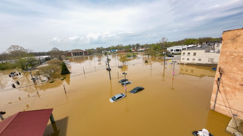
Severe thunderstorms and relentless rain are triggering catastrophic flooding across the middle of the US this weekend, as areas already hit hard by a recent string of storms and tornadoes remain in the path of this current system. The storms have killed at least 16 people across Tennessee, Missouri, Indiana, Arkansas and Kentucky since Wednesday. In Franklin County, Kentucky, a 9-year-old boy was swept away by floodwaters while walking to his school bus stop, police said. And in Little Rock, Arkansas, a 5–year-old was killed at a home battered by severe weather. There are 41 million people at risk for severe storms Saturday from the Ohio River Valley southwestward to southeast Texas, according to the Storm Prediction Center. Saturday is the third consecutive day of level 4 of 4 risk of flooding rain across the Mississippi Valley, including parts of Arkansas, Missouri, Tennessee and Mississippi. Residents in these areas will likely see the peak of “life-threatening” flash floods on Saturday afternoon to evening, when rainfall will be at its heaviest. The three-day stretch of the highest possible flooding threat is almost unheard-of outside hurricane season. Very heavy showers and thunderstorms will continue to move repeatedly over portions of central and eastern Arkansas and western Tennessee over the next few hours. The high rainfall rates from these storms will lead to life-threatening and locally catastrophic flash flooding. The storms have already prompted tens of thousands of power outages across the region and delays for more than 6,000 flights within, into or out of the US on Saturday. As of Saturday, 36 million people were under flood watches and ongoing rain prompted over two dozen flash flood warnings from northeast Texas to southern Illinois. In some areas of Tennessee, Mississippi and Arkansas, flash flood emergencies – the highest level of flood warning – have been issued through Saturday evening. The possibility of “generational” flooding that the National Weather Service warned about this week stems from a stagnation in the current weather pattern that’s caused the string of storms to repeatedly hit the same areas in the central and southern US. By Sunday, the “stuck” pattern will finally start to break, and the storms will begin to push eastward. Storm threats will remain in effect for Florida Panhandle, Alabama and Georgia on Sunday, while the flood threat for Arkansas, Tennessee and Kentucky should lessen by Sunday afternoon. Flooding overwhelms homes and roads, leading to multiple water rescues Authorities in West Plains in southern Missouri carried out as many as a half a dozen water rescues as of late Friday, according to CNN affiliate KY3. At least half a dozen different fire departments were assisting in the rescues as part of a task force to help the inundated city. A woman in West Plains was taken to the hospital after being struck by lightning, KY3 reported, citing the city’s emergency manager. CNN has reached out to officials about the woman’s condition. The Missouri State Highway Patrol urged residents to stay off the roads as night fell Friday, warning that “darkness hides dangers like water-covered paths, leading to fatal situations.” The highway patrol statement noted troopers were already “busy rescuing stranded motorists who underestimate the risks.” Videos obtained by CNN show rushing water covering part of a state highway in Howell County, Missouri, west of West Plains. The highway patrol told CNN it was “just one example of many other low water crossing areas.” Earlier Friday, authorities carried out 15 water rescues in Van Buren, Missouri, about 65 miles east of West Plains. Van Buren was hit with 3 inches of rain over a short period. The Black River near Poplar Bluff is projected to approach a level of “major flooding” category this weekend. On Friday, the Army Corps of Engineers said it had filled roughly 1,500 sandbags to bolster the nearby levee. Areas from far northeastern Texas to Kentucky are expected to feel the greatest impact from the floods –– locations left vulnerable by the recent tornadoes. More than a foot of rain falling in a matter of days on areas in Arkansas to Kentucky could bring historic, once-in-a-generation flooding, forecasters warn. In northern Arkansas, the city of Hardy experienced significant flooding overnight, as the Spring River reaches historic water levels. Water rescues were ongoing overnight Friday into Saturday, with Sharp County Sheriff Shane Russell personally rescuing three dogs, he told CNN. Hardy Mayor Ethan Barnes said more than half of the city’s residents will be impacted by high waters this weekend. “We’ve been heavily impacted over the last few days,” A.J. Gary, the director of Arkansas Division of Emergency Management, told CNN Saturday afternoon. So far, at least 12 people have been injured across the state, the Arkansas Division of Emergency Management said. In Mammoth Spring, Arkansas, a train was stopped on a bridge due to multiple active weather warnings in the area early Saturday morning, when heavy flood waters washed out the bridge and derailed multiple cars, according to BNSF Railway. BNSF personnel were on site coordinating with Mammoth Spring State Park to clear the incident and repair the bridge Saturday afternoon. Some of the train cars were fully underwater, with nonstop rain from the early hours of the morning complicating recovery efforts. Meanwhile, more than 83,000 homes and businesses throughout the state were left without power as of Saturday night, according to poweroutage.us. Flash flood emergencies are in effect for two different parts of Arkansas due to torrential rains, according to the weather service office in Little Rock. A flash flood emergency is the highest level of flood warning, only issued when extremely heavy rain is leading to a severe threat to human life and catastrophic damage from a flash flood is happening or will happen soon. President Donald Trump on Saturday approved Arkansas’ request for an Emergency Declaration for Direct Federal Assistance to assist the state with its response to storms, tornadoes, and flooding, Gov. Sarah Huckabee Sanders said. In Kentucky, there were 390 road closures across the state on Saturday morning due to flooding, mudslides and rockslides, Gov. Andy Beshear said. Beshear declared a state of emergency for the western part of the state, citing potentially record rainfall in areas unaccustomed to flooding. Residents of Jessamine County, Kentucky, traveled through floodwaters in boats as water encircled buildings along the Kentucky River and houses were partially submerged, videos show. Louisville, Kentucky has already seen impacts on daily life as the Ohio River has risen over five feet over the last 24 hours – and it’s expected to rise significantly higher over the next two to three days, Mayor Craig Greenberg said Saturday afternoon. Drone video released from downtown Hopkinsville, Kentucky, on Friday showed the scale of the widespread destruction left behind in the city after the area was pounded by rain this week. In the video, buildings, cars and roads were partially submerged by water. “Right now we’re kind of going under a flood, which I had been through once before in 1997. The water had come up and came into the business,” said Tony Kirves, a Hopkinsville resident whose photography studio flooded from the storm. Around him, cars were submerged in water. Numerous front doors of businesses also appear flooded. “We’ve been trying to maintain this water by sandbagging and using shop vacs and some pumps, but it’s just too massive of an amount to kind of control,” Kirves said. According to the National Weather Service, between 5 and 8 inches of rain fell in Hopkinsville from Thursday night to Friday. In Van Lear, Kentucky, on Friday, “swift water technicians” rescued six people from their homes, which the W.R. Castle Fire-Rescue described to be surrounded by water, according to a post on Facebook. The fire department said first responders went door to door in the Silk Stocking Loop, now inundated with stormwater, to check on residents’ safety. Kentucky is one of the handful of states in the region to have sustained repeated damage from a string of deadly storms. In February, a deadly winter storm claimed several lives, and in 2021, the state faced another large-scale flash-flooding disaster. Fresh threat of tornadoes Dozens of tornadoes have been reported across the central US this week, with some stronger ones possible in Arkansas, Louisiana, Texas, and the Lower Mississippi Valley throughout the weekend. Tornadoes forming Saturday mark the 10th day in a row with tornadoes somewhere in the country. In each of the last seven days, tornadoes have occurred east of the Mississippi River. The highest risk zone, level 3 out of 5, impacts more than 10 million people from just west of Nashville southward to just north of Houston and includes those cities, along with Memphis, Tennessee; Jackson, Mississippi; Shreveport and Alexandria in Lousiana; and Lufkin, Texas. These are places where strong tornadoes reaching EF 2 intensity (winds over 111 mph) are likely to form. Additionally, large hail about golf-ball sized or larger is possible along with damaging wind gusts. Some of these areas, especially in western Tennessee and eastern Arkansas, have endured tornadoes for the past several days. Selmer, Tennessee, a town about 90 miles east of Memphis, was hit hard by a tornado that broke out on Wednesday, with residents of a newly built apartment complex scrambling for shelter as the storm struck. “Most people took shelter in their laundry rooms inside of the apartments,” said resident Justin West, whose unit survived while the front of the complex was “almost gone.” West witnessed cars destroyed in the parking lot, piles of debris and sections of the roof torn away. The complex opened less than a year ago, he pointed out. Tennessee Gov. Bill Lee urged residents to stay alert, warning that despite widespread damage and destruction, “this storm is going to continue.” Tornado sirens in Nashville were sounding so frequently its loudspeakers ran out of battery on Thursday, remaining inoperable until power was restored, city emergency officials said. On Friday, there were 80 nationwide reports of severe weather, which included 13 tornado reports, 42 hail reports and 25 wind reports. Tennessee has so far been the state with the highest storm-related death toll, with at least ten deaths reported by Saturday. As of Saturday night, more than 56,000 homes and businesses in the state were without power. In Missouri, a tornado swept through the small city of Pilot Grove on Wednesday, leaving a trail of scattered debris, CNN affiliate KOMU reported. Among those affected was Justin Gerke, who rushed home after receiving an alert. “I got a tornado warning alert on my phone and came home as soon as I could from work,” Gerke told KOMU. When he arrived, he found the roof of his childhood home ripped off, the garage obliterated, and several destroyed cars. In Nevada, Missouri, the storm left widespread damage to a former motel now serving as student housing for the Missouri Welding Institute, a trade school specializing in welding and metal fabrication. The family-owned property, which houses approximately 50 students, sustained significant damage, residents told CNN affiliate KSHB. “This is our heart and soul,” Shari Snyder, who operates Nevada Oaks, told KSHB. “We love this place, my dad put everything into this place, and the students loved it here.” While no students were injured in the storm, the tornado shattered windows and destroyed several cars in the parking lot, the affiliate reported. Damage was reported in northeast Texas Friday following a series of reported tornadoes. In Wood County, one person was injured and at least one house was damaged by toppled trees, according to county emergency officials. Damage survey teams from the National Weather Service have given preliminary ratings to at least 31 tornadoes in eight states since the outbreak began Wednesday. So far, they have found three tornadoes of at least EF3 out of EF5 strength in Missouri, Tennessee and Arkansas. Additional surveys could take days to complete and some have been held up by the continuing hazardous weather. This story has been updated with additional information. CNN Meteorologists Brandon Miller, Mary Gilbert and CNN’s Sarah Dewberry, Sara Smart, Taylor Romine, Jillian Sykes, Hanna Park, Chris Youd, and Holly Yan contributed to this report. CNN’s Michael Yoshida contributed from Mammoth Spring, Arkansas.
Thunderstorms trigger catastrophic flooding across the middle of the US
TruthLens AI Suggested Headline:
"Severe Thunderstorms and Flooding Cause Widespread Damage Across Central U.S."
 CNN
7.5
CNN
7.5
TruthLens AI Summary
Severe thunderstorms have wreaked havoc across the central United States, resulting in catastrophic flooding that has claimed at least 16 lives across multiple states including Tennessee, Missouri, Indiana, Arkansas, and Kentucky. The storms began earlier in the week and have continued to intensify, with a significant number of regions experiencing relentless rain and life-threatening flash floods. In Franklin County, Kentucky, a tragic incident occurred when a 9-year-old boy was swept away by floodwaters while on his way to a school bus stop. Little Rock, Arkansas, also faced tragedy as a 5-year-old lost their life due to severe weather impacts. Approximately 41 million people are currently at risk for severe storms, with the Storm Prediction Center highlighting a level 4 out of 4 risk for flooding rain across the Mississippi Valley. The ongoing weather system has led to widespread power outages and significant disruptions, including over 6,000 flight delays nationwide on Saturday alone. Residents in the affected areas are bracing for peak flooding conditions, expected Saturday afternoon and evening, as the three-day flooding threat escalates, a scenario that is often unprecedented outside of hurricane season.
In addition to the immediate dangers posed by flash flooding, emergency responders are actively conducting water rescues across inundated areas. In West Plains, Missouri, authorities executed multiple rescues as floodwaters surged, while the Missouri State Highway Patrol has warned residents to avoid road travel due to hidden dangers posed by flooded paths. The situation is compounded by reports of tornadoes in the region, with numerous tornadoes recorded across the central U.S., including EF2 intensity storms. As states grapple with the aftermath of these severe weather events, President Donald Trump has approved an emergency declaration for Arkansas to aid in disaster response efforts. With record rainfall predicted, officials are urging residents to remain vigilant as the threat of flooding and additional severe weather persists. Communities in Kentucky are also facing significant challenges, as flooding has led to numerous road closures and emergency declarations, highlighting the widespread impact of this severe weather system across the region.
TruthLens AI Analysis
Severe thunderstorms and flooding have become a pressing concern across the central United States, with the article highlighting the dire consequences of these weather events. The report reflects not only on the immediate devastation caused by the storms but also on the broader implications for communities already struggling with prior disasters.
Purpose of the Article
The primary intention behind this report appears to be raising awareness about the catastrophic flooding and the immediate dangers posed by the severe weather. It aims to inform the public about the situation, encouraging vigilance and preparedness among those in affected areas. By detailing the loss of life and the potential for "life-threatening" flash floods, the article seeks to elicit a sense of urgency and concern.
Public Sentiment and Perception
The language used in the article fosters a sense of fear and urgency, which is typical in disaster reporting. By emphasizing the risk to millions and the tragic stories of individuals affected, the article generates empathy and a call to action for readers to be aware of the conditions in their areas.
Omissions and Hidden Agendas
While the article provides a comprehensive overview of the flooding and its impacts, it may not address the underlying issues contributing to these extreme weather patterns, such as climate change. This omission could lead readers to overlook the systemic factors that exacerbate such disasters, potentially downplaying the need for broader societal discussions and actions regarding climate resilience.
Credibility and Reliability
The report appears credible, citing specific incidents, locations, and official warnings from the Storm Prediction Center. The mention of fatalities and the scale of the flooding adds to the authenticity of the narrative, making it a reliable source for understanding the current situation.
Comparison with Other Reports
When compared to other reports on natural disasters, this article follows a familiar structure, focusing on the immediate impacts and human stories. However, it lacks a deeper exploration of long-term implications or comparisons to past events, which could provide a fuller context for readers.
Potential Societal and Economic Impact
The information presented has significant implications for communities, economies, and local politics. The devastation from floods can lead to long-term economic challenges, especially in agriculture and infrastructure. Additionally, the response from local and federal authorities may influence political dynamics, particularly regarding disaster preparedness and response funding.
Target Audience
The article primarily appeals to communities in the affected regions, as well as broader audiences interested in weather-related news and safety information. It targets individuals who may be vulnerable to such natural disasters, urging them to take precautions.
Market Influence
Natural disasters can have immediate effects on financial markets, particularly for insurance companies, construction firms, and utility providers. The report's emphasis on power outages and disrupted travel may influence stock prices in these sectors, as investors assess the potential financial fallout from the flooding.
Geopolitical Context
While the flooding is primarily a domestic issue, it reflects broader trends in climate change and disaster response that resonate globally. The increased frequency of severe weather events is a point of concern in international discussions about climate policy and disaster preparedness.
Use of AI in Reporting
There is no direct evidence in the article suggesting that AI was used in its writing. However, if AI were involved, it could have influenced the language and framing of the narrative, potentially steering the focus towards sensational aspects of the story for greater impact.
The article's language, while informative, may also serve to manipulate public emotion by highlighting tragic personal stories and urgent warnings, which could be seen as a tactic to increase engagement with the news.
In conclusion, the article effectively conveys the gravity of the situation, emphasizing both the immediate impacts and the broader implications of severe weather events. Its reliability is supported by factual reporting, though it may benefit from a more nuanced discussion of underlying causes and long-term effects.