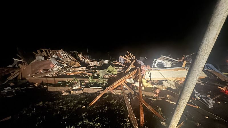
A relentless stretch of severe weather that left 28 dead and unleashed destruction across the central and eastern United States in recent days isn’t letting up yet, with millions more in the path of dangerous weather this week. Monday’s level 4-of-5 risk of severe thunderstorms in the Plains marks the third day out of the last four to hit this rare level – one typically issued on about 10 days each year. All severe thunderstorm hazards are expected– including tornadoes that could reach EF3 strength or greater. Oklahoma City and Tulsa, Oklahoma, are within the most concerning risk area Monday, but Dallas, Kansas City and St. Louis, including areas devastated on Friday, could also be in the path of dangerous storms. Here’s the latest: Significant tornado risk forecast once again Multiple rounds of severe weather will target the Plains on Monday, bringing the threat of damaging wind gusts stronger than 80 mph, hail bigger than softballs and strong or intense – greater than EF3 –tornadoes. “Everyone needs to stay weather aware today/tonight and have a plan in place in case you need to shelter,” the National Weather Service in Norman, Oklahoma, urged. A level 4-of-5 risk of severe thunderstorms is centered on more than 5 million people in the eastern half of Oklahoma – including Oklahoma City – and portions of surrounding states on Monday, according to the SPC. A larger level 3-of-5 risk includes more than 12 million people elsewhere in the Plains and Mississippi Valley. The most dangerous activity in Kansas and Oklahoma is expected to begin later Monday afternoon and push east into the Mississippi Valley overnight, but a few damaging storms could rumble to life earlier in the afternoon – especially in northern Texas, including the Dallas-Fort Worth metroplex. The greatest risk of tornadoes will start when storms first fire up in the late afternoon and continue through the evening, with the SPC warning of long-lived supercells – rotating thunderstorms capable of producing violent impacts – that could travel large distances. Oklahoma is at the greatest threat for these storms, but they’re also possible in surrounding states. A dangerous flash flooding threat will also build just east of where the strongest thunderstorms are set to strike. A level 3-of-4 risk of flooding rainfall is in place for parts of northern Arkansas and southern Missouri, according to the Weather Prediction Center. These areas have been soaked in recent weeks, so any additional heavy rain could produce “numerous flash floods.” The severe weather threat will shift east on Tuesday, targeting parts of the Mississippi, Ohio and Tennessee valleys — including areas that have already been hit hard by this spring’s storms, like western Kentucky and western Tennessee. Damaging wind gusts, hail and tornadoes are once again possible within any storm on Tuesday. Some areas, especially parts of the Ohio Valley, could start the day with lingering severe storms from Monday night. Additional storms are likely to develop Tuesday afternoon in the Mississippi Valley and push east through the evening. Multiple tornadoes hit Kansas Sunday Tornadoes tore through Kansas on Sunday night, prompting two tornado emergencies in the central part of the state: one for Plevna and one for Greensburg. In Plevna, roughly 60 miles from Wichita, Reno County Sheriff Darrian Campbell said a passing tornado Sunday night caused significant damage to homes. It was a close call for Greensburg, but the city made it through the night relatively unscathed, CNN affiliate KWCH reported. That wasn’t the case elsewhere in the state. A “large and extremely dangerous tornado” roared through Grinnell in northwestern Kansas on Sunday evening, according to the NWS. Photos from the town show debris scattered everywhere, with severely damaged homes, blocked roads and overturned vehicles. One image shows a local church with its roof blown off. Midwest Energy reported the tornado caused damage to both electric and gas systems in the Grinnell area, according KWCH. Until Sunday night, Kansas had largely avoided tornadoes this spring, which is unusual for the state. May is the peak of tornado season for the US, with much of that activity typically centered in the Plains. Five consecutive days of damaging storms Ferocious storms have carved through hundreds of miles of the US in recent days, generating more than 1,500 reports of damaging wind gusts, hail and tornadoes since Wednesday. About 100 of those reports were tornadoes. National Weather Service storm survey teams are still picking through extensive damage to determine exactly how many tornadoes tore through the central and eastern US since last week, but they’ve already found at least three EF3 tornadoes and one EF4. The EF4 tornado tore through Williamson County in southern Illinois on Friday, injuring at least seven people as it damaged homes and obliterated trees. An EF3 tornado rocked the St. Louis area Friday, according to the NWS, reaching its peak intensity as it stretched a mile wide over the north side of the city. The tornado killed at least five people and injured dozens, while also “damaging or destroying thousands of buildings.” Deadly storms also left vast destruction behind in Laurel County, Kentucky, over the weekend. The city of London was hit particularly hard. Police in Corbin, south of London, were responding to mutual aid calls for tornado victims and described the devastation as overwhelming. “Stop and pray for Laurel County residents and victims of the tornado that touched down there,” the department wrote.
Strong tornadoes threaten millions more in the central US after a weekend of violent storms that left at least 28 dead
TruthLens AI Suggested Headline:
"Severe Weather Continues to Threaten Central US Following Deadly Weekend Storms"
 CNN
7.4
CNN
7.4
TruthLens AI Summary
The central and eastern United States is currently facing a continuation of severe weather, which has already resulted in the deaths of at least 28 individuals and widespread destruction across several states. On Monday, a level 4-of-5 risk of severe thunderstorms was issued, marking an alarming trend as this is the third such warning in just four days. The National Weather Service has cautioned that tornadoes, potentially reaching EF3 strength or higher, are expected to form, particularly in Oklahoma City and Tulsa. Over 5 million people are under the most severe threat in Oklahoma, while an additional 12 million are at risk in the wider Plains and Mississippi Valley regions. The storms are anticipated to bring not only tornadoes but also damaging winds exceeding 80 mph and hail larger than softballs. The severe weather is expected to begin in the late afternoon, with supercells capable of producing long-lived tornadoes that could travel significant distances, raising concerns for areas already affected by recent storms.
In addition to the tornado threat, the risk of flash flooding is increasing, especially in parts of northern Arkansas and southern Missouri, where recent rains have saturated the ground. Following the severe weather on Monday, the risk is expected to shift eastward on Tuesday, affecting the Mississippi, Ohio, and Tennessee valleys, including regions that have already been devastated this spring. Tornadoes struck Kansas on Sunday night, resulting in significant damage in areas like Plevna and Grinnell, where homes were destroyed and utility systems were impacted. National Weather Service teams are still assessing the damage and have confirmed multiple tornadoes, including at least three EF3s and one EF4, from the previous week's storms. As communities continue to recover from the devastation, officials are urging residents to remain vigilant and prepared for the ongoing severe weather threat.
TruthLens AI Analysis
The recent news report highlights the severe weather conditions affecting the central and eastern United States, resulting in loss of life and extensive damage. The article emphasizes the imminent threat of tornadoes and other severe weather phenomena, urging the public to remain vigilant and prepared. This narrative serves multiple purposes, including informing the public about the risks and potentially influencing awareness and preparedness.
Purpose of the Report
The intention behind this article could be to raise awareness about the ongoing severe weather events and their potential consequences. By detailing the severity of the situation, it aims to encourage individuals and communities to take necessary precautions. This kind of reporting can also help in mobilizing emergency response efforts and resources.
Public Sentiment and Awareness
The report seeks to create a sense of urgency among the population, particularly those in the affected areas. By emphasizing the number of people at risk and the potential for catastrophic outcomes, it may foster a communal sense of vigilance and readiness. The article's dramatic tone could also be intended to stimulate discussions about climate change and its impacts on extreme weather events.
Potential Omission of Information
While the article focuses heavily on the immediate dangers of tornadoes and severe storms, it may not delve into the underlying causes of such extreme weather, such as climate change or systemic issues in disaster preparedness. This omission could lead to a skewed understanding of the broader context of weather phenomena.
Trustworthiness of the Report
The report appears to be grounded in factual data, citing sources such as the National Weather Service and the Storm Prediction Center. However, the sensational tone and focus on the most severe outcomes could contribute to a perception of fear-mongering. Overall, while the core information is reliable, the manner of presentation may raise questions about its objectivity.
Comparative Analysis
In comparison to other reports on severe weather, this article leans heavily into the dramatic aspects of the storm's impact. Other news outlets may provide a more balanced view, including information on recovery efforts or historical context regarding similar weather patterns. The framing of this article could thus be viewed as aligning with a trend in media to prioritize sensationalism over comprehensive reporting.
Impact on Society and Economy
The implications of this report extend beyond immediate weather concerns. It could prompt discussions on infrastructure resilience, emergency management policies, and even climate change legislation. Economically, businesses might prepare for disruptions, and insurance companies could see increased claims as a result of the destruction.
Target Audience
The article is likely aimed at a broad audience, particularly those living in the affected regions. It may resonate more with communities that have previously experienced severe weather, as well as individuals with a vested interest in disaster preparedness and response.
Market Influence
This kind of reporting might affect financial markets, particularly sectors related to insurance, construction, and emergency services. Companies that specialize in storm recovery and infrastructure repair could see increased interest and stock performance as consumers and governments prepare for the aftermath of severe weather events.
Geopolitical Considerations
While primarily focused on a domestic issue, the article touches on themes relevant to global climate discussions. The increasing frequency of extreme weather events may influence international policy dialogues concerning climate action and disaster preparedness.
Use of AI in Reporting
It is plausible that AI tools were employed in drafting or editing the article. These models might have shaped the narrative to emphasize urgency or to streamline information presentation. However, without explicit acknowledgment from the publisher, it's difficult to ascertain the extent of AI influence.
In conclusion, the article serves to inform the public about an urgent weather situation while simultaneously raising awareness about broader issues related to climate and preparedness. Its reliability is generally strong, although the sensational tone may detract from a more nuanced understanding of the situation.