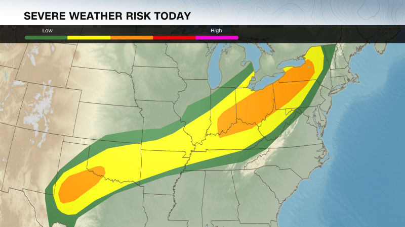
New rounds of severe thunderstorms and life-threatening, potentially catastrophic, flooding risks are brewing in the central and eastern United States Tuesday, putting more than 50 million people at risk of dangerous weather this week. The threats come on the heels of Monday’s storms, which unleashed damaging wind gusts, hail bigger than baseballs and tornadoes. Some of Monday night’s storms were ongoing Tuesday morning in parts of Oklahoma, prompting multiple severe thunderstorm warnings and a flash flood warning for Oklahoma City. More of the same is expected to unfold in multiple states Tuesday. A massive, 1,800-mile stretch of the country from West Texas to Vermont is within a level 2-of-5 risk of severe thunderstorms on Tuesday, according to the Storm Prediction Center. Two smaller but more significant level 3-of-5 risks are in place for parts of Ohio, Pennsylvania and New York and parts of Texas and Oklahoma. Multiple rounds of storms will move through the Southern Plains Tuesday. The first round was ongoing Tuesday morning from northern Texas to southern Kansas. Additional strong to severe storms are possible throughout the day, with the strongest storms possible by the evening. Storms in this area could produce large hail, damaging winds and tornadoes. They could also dump rounds of heavy rain, putting the risk of dangerous flooding on the table in what forecasters warn could become a multi-day flood event. A level 3-of-4 risk of flooding rain is in place for parts of northern Texas and much of Oklahoma – including Oklahoma City and Tulsa – according to the Weather Prediction Center. The area is primed for widespread flash flooding that could become life-threatening in some instances, the WPC warned. Rounds of heavy rain over the past few weeks have drenched the ground and made it vulnerable to flooding as the soil won’t be able to soak up any excess moisture. In Oklahoma, flash flooding from storms the weekend prior prompted high-water rescues and left at least five people dead. Flash flooding was already ongoing in the Oklahoma City area Tuesday morning, and the situation will only deteriorate there and in nearby areas as additional storms hit the area. Southwest Oklahoma could experience “locally catastrophic” flooding, the National Weather Service warned. Severe thunderstorms are also possible for parts of the Mississippi Valley, Midwest and Northeast on Tuesday. Storms in parts of Missouri and Arkansas are possible throughout much of the day with any storms farther north and east more likely to begin in the afternoon. Storms that develop farther north Tuesday afternoon will likely start in southern Ontario, Canada, and then track into parts of Ohio, Pennsylvania and New York in the evening. Damaging wind gusts are the main threat with these storms, but some could drop large, egg-sized hail and tornadoes. Stormy weather and periods of heavy rain will persist Wednesday, with a level 3-of-4 risk of flooding rainfall in place for parts of Texas, Oklahoma, Missouri and Arkansas. A few severe thunderstorms are possible in the Southern Plains on Wednesday, but widespread chances of damaging storms fade for the rest of the week.
Oklahoma could see ‘catastrophic’ flooding as severe weather threats stretch from Texas to Vermont
TruthLens AI Suggested Headline:
"Severe Weather Threats and Flooding Risks Expand Across Central and Eastern U.S."
 CNN
8.6
CNN
8.6
TruthLens AI Summary
The central and eastern regions of the United States are currently facing significant severe weather threats, including the potential for catastrophic flooding. On Tuesday, over 50 million people are at risk as new thunderstorms develop following Monday's severe storms, which already caused damaging winds, large hail, and tornadoes. Oklahoma is experiencing the brunt of these conditions, with ongoing severe thunderstorm warnings and flash flood warnings in place for cities such as Oklahoma City. The Storm Prediction Center has indicated a wide area, stretching 1,800 miles from West Texas to Vermont, is under a level 2-of-5 risk for severe thunderstorms, with more localized areas in Ohio, Pennsylvania, New York, Texas, and Oklahoma facing even higher risks of severe weather. The threat of heavy rain is particularly concerning, as the region is primed for flash flooding, especially in Oklahoma, where previous storms have already saturated the ground, making it difficult for soil to absorb additional moisture.
As the weather continues to develop, Oklahoma and parts of northern Texas are under a level 3-of-4 risk for flooding rain, raising alarms about potentially life-threatening flash floods. The National Weather Service has warned that southwest Oklahoma could see locally catastrophic flooding, with conditions expected to worsen as additional storms roll through the area. In addition to Oklahoma, severe thunderstorms are also anticipated in the Mississippi Valley, Midwest, and Northeast, with damaging wind gusts, large hail, and tornadoes possible. Storms are expected to persist into Wednesday, with continued risks of heavy rainfall across Texas, Oklahoma, Missouri, and Arkansas. While the severe weather is likely to diminish later in the week, the immediate focus remains on the ongoing threat of flooding and severe thunderstorms affecting millions across the region.
TruthLens AI Analysis
The article outlines the severe weather threats facing a large area of the central and eastern United States, particularly highlighting the risks of catastrophic flooding in Oklahoma and surrounding states. It emphasizes the potential for life-threatening conditions as storms are predicted to affect millions of people.
Purpose Behind Publication
The intention behind this article seems to be to inform the public about the imminent severe weather and associated risks. By providing detailed forecasts and warnings, the article aims to prompt individuals and communities to take necessary precautions. It serves as a reminder of the power of nature and the importance of preparedness during such events.
Public Perception
The article likely aims to create a sense of urgency among readers, emphasizing the seriousness of the weather conditions. This can foster a heightened awareness of climate-related disasters, potentially leading to increased community engagement in preparedness activities or support for disaster management initiatives.
Omissions or Hidden Information
There does not appear to be a significant effort to conceal information in this article. The focus seems to be on providing clear and actionable information regarding the weather risks. However, it could be argued that the broader context of climate change and its long-term implications is not addressed, which might leave readers unaware of the systemic issues contributing to such severe weather patterns.
Manipulative Elements
The article's manipulation rate can be considered low, as it primarily presents factual weather forecasts and warnings without sensationalizing the information. The use of terms like "catastrophic" and "life-threatening" does enhance the urgency but remains appropriate given the context. The language used is direct and serves to inform rather than mislead.
Comparison with Other News
This piece aligns with other weather-related news articles, particularly in the context of increasing extreme weather events attributed to climate change. There may be a connection to broader narratives about resilience and sustainability in the face of climate challenges, as similar articles address various regions experiencing severe weather.
Impact on Society, Economy, and Politics
Potential consequences of this article include increased public awareness and response to severe weather, influencing local government actions regarding emergency preparedness. Economically, areas affected by flooding may see disruptions in business and infrastructure, which could lead to political discussions regarding funding for disaster relief and infrastructure improvements.
Target Audience
The article caters primarily to residents of the affected regions, emergency services, and local governments. Its focus on severe weather alerts and preparedness measures particularly resonates with communities that frequently deal with such conditions.
Market Impact
While the article itself may not directly influence stock markets, companies involved in disaster response, construction, and insurance may see fluctuations based on public perception and potential damages from the weather events discussed. Investors in these sectors may be particularly attentive to such news.
Geopolitical Considerations
The article does not directly address global power dynamics but does reflect an increasing trend of extreme weather events that can have geopolitical implications, especially in discussions around climate policy and international aid in disaster situations.
AI Involvement
It is plausible that AI tools were used in drafting this article, especially for data analysis and predicting weather patterns. The structured nature of the report and the use of statistical risk levels suggest a systematic approach that could benefit from AI models designed for meteorological data interpretation.
Overall, the article is credible, relying on established meteorological data and warnings from recognized authorities. It effectively communicates the urgency of the situation while providing essential information for public safety.