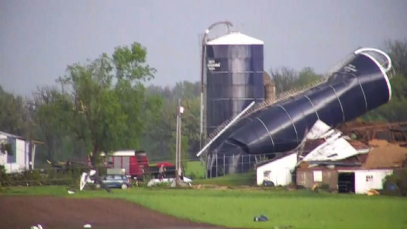
An incredibly dangerous day of severe thunderstorms including the potential for long-lasting, powerful tornadoes and hurricane-strength wind gusts is ahead for the eastern half of the United States Friday. The threat for tornadoes and damaging winds is escalating after the same system already produced destructive storms and tornadoes in the Midwest and Great Lakes Thursday. It’s all part of a multi-day threat of widespread severe weather that will stretch into early next week. Here’s the latest: Powerful storms are shaping up Friday Some severe thunderstorms from Thursday night were ongoing from Arkansas through Kentucky early Friday morning, but those are expected to clear out quickly and give the atmosphere enough time to refuel for another, more violent round of storms beginning in the afternoon. “A regional outbreak of severe thunderstorms is likely this afternoon into tonight,” the SPC warned Friday, adding some people in the path of storms will see “intense supercells.” More than 70 million people in the eastern half of the US are under at least a level 2-of-5 threat of severe thunderstorms on Friday, but the greatest risk of long-lasting, EF3-plus tornadoes and widespread damaging winds is centered on parts of the Mississippi and Ohio Valleys. “All severe weather hazards are on the table, including damaging winds, large hail, tornadoes, and torrential rainfall,” the National Weather Service in Louisville, Kentucky, warned. “A few strong tornadoes and instances of very large hail are possible.” Storms should fire up in parts of Missouri, Arkansas and Illinois in the afternoon and expand rapidly in scope as they push east. Initial storms are those most likely to become supercells capable of producing tornadoes, damaging wind gusts and large hail. That threat will continue into the evening before some storms start to form unbroken lines. The wind threat will increase once storms form lines, with gusts stronger than 75 mph and damage possible over hundreds of miles. Dangerous storms could continue after dark, particularly in parts of Kentucky and areas east. It’s a threat to be especially mindful of as nighttime tornadoes are nearly twice as likely to be deadly as those occurring during the day, a 2022 study found. Storms leave damage in their wake At least 11 tornadoes were reported in Minnesota, Wisconsin and Illinois as thunderstorms roared through the Midwest Thursday. Significant damage was reported in Dodge County, Wisconsin, as a cluster of storms around the county prompted shelter-in-place alerts and displaced residents, according to Sheriff Dale Schmidt. One person was taken to the hospital with injuries in Juneau, the sheriff said, adding there “may have been another minor injury or two that occurred.” Many streets and highways in the county are closed due to downed power lines and trees, Schmidt said. Multiple homes in Juneau were damaged and at least one house suffered a roof collapse. Everyone inside was able to get out safely, he added. Powerful winds also slammed multiple states. A weather reporting station on Lake Michigan near Chicago’s Navy Pier recorded a hurricane-strength wind gust of 79 mph in the evening. Nearly 400,000 homes and businesses across five Midwest states were without power Friday morning, including more than 250,000 in Michigan, according to PowerOutage.us. Michigan utitlity company Consumers Energy said assessments on power restoration are still waiting to be made, according to CNN affiliate WNEM. Damaging storm risks persist for days Severe thunderstorms are possible in the Mid-Atlantic and Northeast on Saturday as the same storm driving Thursday and Friday’s threats pushes east. Damaging wind gusts and hail are the greatest threats for now, but a tornado can’t be ruled out. New storms could bring damaging wind gusts, hail and tornadoes to parts of the southern Plains starting Saturday afternoon. The Plains will remain the main focus of severe weather on Sunday and Monday as well, with damaging storms possible in much of Oklahoma and Kansas. The severe thunderstorm threat will then shift back into parts of the Mississippi Valley on Tuesday. More details about the exact risks these storms will pose and the populations under threat next week will become clear in the coming days.
Millions under threat of strong tornadoes and violent winds as storm danger increases Friday
TruthLens AI Suggested Headline:
"Severe Thunderstorm Threat Expands Across Eastern US with Tornado Risks"
 CNN
7.5
CNN
7.5
TruthLens AI Summary
Friday is shaping up to be an extremely dangerous day for severe thunderstorms across the eastern half of the United States, with the potential for long-lasting, powerful tornadoes and hurricane-strength wind gusts. The severe weather threat has escalated following destructive storms that swept through the Midwest and Great Lakes on Thursday. As the atmosphere refuels during the day, a regional outbreak of severe thunderstorms is anticipated, particularly in the afternoon and evening. The Storm Prediction Center (SPC) has warned that over 70 million people are at least under a level 2-of-5 threat for severe weather, with the most significant risks of EF3-plus tornadoes and widespread damaging winds concentrated in the Mississippi and Ohio Valleys. The National Weather Service has cautioned that all severe weather hazards could occur, including damaging winds, large hail, and torrential rainfall, further highlighting the potential for a few strong tornadoes and instances of very large hail. Storms are expected to develop in Missouri, Arkansas, and Illinois, rapidly expanding eastward with the initial storms being most likely to produce supercells capable of generating tornadoes and damaging gusts.
As the severe weather unfolds, the impacts from Thursday's storms are already being felt, with reports of at least 11 tornadoes across Minnesota, Wisconsin, and Illinois. Significant damage was noted in Dodge County, Wisconsin, prompting shelter-in-place alerts and displacing residents. One individual was hospitalized, and numerous streets remained closed due to downed power lines and trees. Wind gusts recorded near Chicago reached hurricane strength at 79 mph, contributing to widespread power outages affecting nearly 400,000 homes and businesses across five states. In the coming days, the severe weather threat is expected to persist, with thunderstorms forecasted for the Mid-Atlantic and Northeast on Saturday, followed by additional risks in the southern Plains through Sunday and Monday. As the storm system continues to move eastward, further assessments of the storm's impact and specific risks for various regions will be made clearer in the days ahead.
TruthLens AI Analysis
The article highlights an imminent and severe weather threat, focusing on the potential for strong tornadoes and damaging winds across the eastern United States. This report aims to inform the public about the dangers posed by the upcoming storms, emphasizing the seriousness of the situation and the need for preparedness.
Public Perception and Awareness
The goal of the article is to raise public awareness regarding severe weather conditions. By detailing the threat level and the specific regions affected, it seeks to instill a sense of urgency among readers. The use of phrases like "incredibly dangerous day" and "long-lasting, powerful tornadoes" serves to underscore the gravity of the situation, encouraging individuals to take necessary precautions.
Potential Omissions and Transparency
While the article provides extensive information about the impending storms, there might be a lack of emphasis on preparedness measures or community resources available to individuals facing such threats. This omission could lead to a sense of helplessness among readers rather than empowering them with actionable steps to mitigate risks.
Manipulative Elements
The report tends to sensationalize the potential impact of the storms, which can be interpreted as manipulative. The language used conveys an extreme sense of danger, which might lead to heightened anxiety among the public. This could be seen as a tactic to ensure that people remain vigilant and aware, but it raises questions about the balance between necessary caution and fear-mongering.
Credibility of the Information
The credibility of the article stems from its reliance on reputable sources such as the National Weather Service and the Storm Prediction Center (SPC). However, the sensational tone may overshadow the factual accuracy, making it essential for readers to discern between genuine concern and hyperbole.
Underlying Connections to Other News
This report may connect to broader narratives regarding climate change and extreme weather patterns, which have been increasingly prevalent in news cycles. The frequency and intensity of severe weather events are often linked to climate discussions, suggesting a larger context to this specific weather prediction.
Societal, Economic, and Political Implications
The impending storms could have significant impacts on local economies, particularly in agriculture and insurance sectors. Additionally, the response to such disasters often influences political discourse surrounding disaster preparedness and climate policies. Communities affected may seek aid, leading to discussions about government responsibility and resource allocation.
Target Audience
The article appears to target a broad audience, particularly those living in regions identified as high-risk. It may resonate more with communities that have previously experienced severe weather events, as they may be more attuned to the language of preparedness and response.
Market Impact
Severe weather reports can influence market behavior, particularly in sectors sensitive to weather conditions, such as agriculture, retail, and insurance. Companies in these industries might experience stock fluctuations based on the severity of the predicted storms and their potential impacts.
Global Context
While the article is primarily focused on a domestic weather event, it reflects broader global trends in extreme weather, drawing attention to the increasing frequency and severity of such occurrences. This aligns with ongoing discussions about global warming and its implications for weather patterns worldwide.
Use of AI in Reporting
There is a possibility that AI tools were employed in drafting the article, particularly for data analysis and summarizing weather forecasts. Models could assist in structuring the report for clarity and impact, although it is difficult to pinpoint specific segments where AI might have influenced the narrative.
In conclusion, the report serves to inform the public about an imminent and severe weather threat while raising awareness of necessary precautions. However, its sensational tone and potential omissions may evoke mixed responses regarding its trustworthiness and intent.