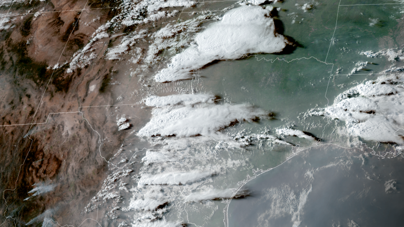
A record-breaking, triple-digit wind gust roared through part of Texas on Tuesday, but it wasn’t from a tornado or a hurricane. An airport weather station in Midland, Texas, recorded a wind gust of 111 mph Tuesday evening – the first triple-digit gust in its 94-year-history in weather reporting. It shattered the previous record of 97 mph set on June 26, 2007. The culprit? A “dry microburst associated virga bomb,” according to the National Weather Service. That’s the technical way to say the atmosphere just threw a knockout punch. To explain what a dry microburst virga bomb really is, we need to zoom out a bit. Microbursts fall under the umbrella of a phenomenon called downbursts, which are strong wind events that develop because of how air moves up and down in thunderstorms. Thunderstorms are fueled by an updraft of warm, rising air. Eventually, some of that air cools, forms precipitation and then a combination of wind and precipitation rushes to the ground in a downdraft. A downburst takes what a typical downdraft produces and cranks it to the extreme. Picture yourself dumping a bucket full of water directly onto the ground: It hits hard and splashes out from the center. Downbursts do just that, but with powerful winds that then move outward at high speeds. The strong winds typically last 5 to 10 minutes at most but can exceed 100 mph in the most extreme cases. Microbursts are downbursts that are less than 2.5 miles wide. Downbursts are typically either wet – precipitation and wind reach the ground – or dry – just wind reaches the ground. Texas’ microburst was dry. As for the “virga bomb” part of the NWS report – that’s just a punchy way to say it was an impressively strong dry microburst. Virga is precipitation that falls from clouds but evaporates before it reaches the ground. Downbursts occur fairly frequently in powerful thunderstorms, but one this extreme is rare. Downbursts become more powerful when they move through a layer of drier air near the ground, as Tuesday’s did. Dry air evaporates precipitation in the downburst at the last second, which actually cools the surrounding air and makes it heavier. Heavier air hits the ground harder, producing stronger winds. Tuesday’s 111 mph gust courtesy of that virga bomb would have been more at home in a hurricane than a random thunderstorm. Category 2 hurricanes, for example, have sustained winds of 96 to 110 mph but often produce gusts stronger than that range. The strongest wind gust ever recorded in Texas stands at 180 mph and was produced by Hurricane Celia in August 1970, according to the state’s climatology office. The hurricane-strength gusts from the fierce virga bomb did not damage Midland’s airport, but did break several power poles and knock over a semi-truck in nearby Odessa, according to the NWS. Other thunderstorms in the same area also produced strong winds that kicked up dangerous dust storms.
A rare virga bomb just shattered a wind record in Texas. Here’s what it is
TruthLens AI Suggested Headline:
"Texas Records Historic 111 mph Wind Gust from Rare Dry Microburst"
 CNN
7.8
CNN
7.8
TruthLens AI Summary
On Tuesday evening, Midland, Texas, experienced an unprecedented weather event when a wind gust of 111 mph was recorded at an airport weather station, marking the first instance of triple-digit wind speeds in the station's 94-year history. This gust exceeded the previous record of 97 mph set in 2007. The National Weather Service attributed this powerful wind to a phenomenon known as a 'dry microburst associated virga bomb.' Microbursts are strong wind events resulting from air dynamics within thunderstorms, where warm, rising air eventually cools and forms precipitation that is then propelled downward. In this particular event, the downburst was classified as dry, meaning it consisted solely of wind, which intensified as it interacted with drier air near the ground, evaporating precipitation just before reaching the surface. This evaporation process cools the air, making it denser and causing it to hit the ground with greater force, thus producing exceptionally high wind speeds.
The term 'virga bomb' highlights the severity of this specific dry microburst, which is rare but can occur when a downburst encounters dry air. The winds generated by this phenomenon are comparable to those found in hurricanes, with the gusts from Tuesday's event being more typical of a Category 2 hurricane, which features sustained winds of 96 to 110 mph. Fortunately, Midland's airport sustained no damage, although the winds did result in downed power poles and overturned vehicles in the nearby area of Odessa. The incident serves as a reminder of the power of severe weather phenomena, as other thunderstorms in the vicinity also produced strong winds and hazardous dust storms, further complicating conditions in the region.
TruthLens AI Analysis
The recent report on a record-breaking wind gust in Texas highlights a unique meteorological phenomenon that caught the attention of both locals and weather enthusiasts. The article serves as an informative piece, aiming to educate the public on the nature of dry microbursts and their impacts, while also instilling a sense of awe regarding the power of nature.
Purpose Behind the Report
The primary aim of the article appears to be raising awareness about extreme weather events and their potential implications. By detailing the specifics of the wind gust and providing a scientific explanation, the article seeks to inform readers about the complexities of meteorological phenomena. This type of reporting can help people understand the significant effects of climate and weather patterns, fostering a more engaged and informed community.
Public Perception and Sentiment
The article encourages a sense of intrigue and respect for natural forces, particularly in the context of Texas, a state known for its varied weather. By presenting the information in a dramatic way—referring to the event as a "virga bomb"—it captures attention and may evoke feelings of both fear and fascination. The use of vivid language serves to create a memorable narrative around an otherwise technical subject.
Potential Omissions or Concerns
While the article focuses on the scientific explanation of the event, it may not address broader implications such as climate change or the increasing frequency of extreme weather events. By narrowing the focus to this singular event, the article might inadvertently downplay ongoing discussions about weather patterns and their long-term changes, which could be a critical aspect for readers to consider.
Truthfulness and Reliability
The article appears to be credible, as it references the National Weather Service and provides a detailed scientific explanation of the phenomenon. However, the sensationalism in the language could be seen as a manipulation tactic to attract readers. While the information is factual, the framing may lead to heightened emotions rather than a calm understanding of the event.
Societal Impact and Future Scenarios
The report could lead to increased public interest in weather preparedness and safety measures, especially in regions prone to such phenomena. It might also stimulate discussions on how climate change could exacerbate the frequency and intensity of weather events, potentially influencing local policies or community initiatives regarding disaster readiness.
Target Audience
This article likely appeals to a diverse audience, including weather enthusiasts, local residents in Texas, and those interested in science and nature. By explaining complex meteorological concepts in relatable terms, it aims to engage a broad spectrum of readers, from casual news consumers to those with a keen interest in meteorology.
Market Implications
While the article itself may not directly influence stock markets, it could have indirect effects on companies involved in weather forecasting technology, disaster management, or safety equipment. Increased awareness and concern about extreme weather could drive demand for services and products that help mitigate the impact of such events.
Geopolitical Relevance
In terms of global power dynamics, the article does not have a direct link. However, it reflects a growing awareness of climate-related issues, which are becoming increasingly significant in international discussions about environmental policy and resilience strategies.
Use of Artificial Intelligence in Writing
There is a possibility that AI tools were leveraged in creating this article, particularly in the structuring of technical information into an accessible narrative. The clear breakdown of meteorological concepts and the engaging writing style suggest an influence of AI in crafting the content, perhaps using models designed for news and educational writing.
In conclusion, while the article does a commendable job of informing readers about a remarkable weather event, its sensational framing may lead to a skewed perception of the broader implications of such phenomena. It successfully engages the audience while leaving some important discussions unaddressed.